
We develop solutions for nature and geosptial data.
Web-ready mapping, analytics, and interfaces that turn complex location data into clear decisions.
Book a Discovery CallSolutions
Specialized geospatial solutions for industries that need precise location intelligence.
Nature Restoration
Custom data solutions for nature restoration—systems that streamline operations, increase transparency, and accelerate fundraising through drone imagery, NDVI analytics, and field-ready dashboards.
Learn more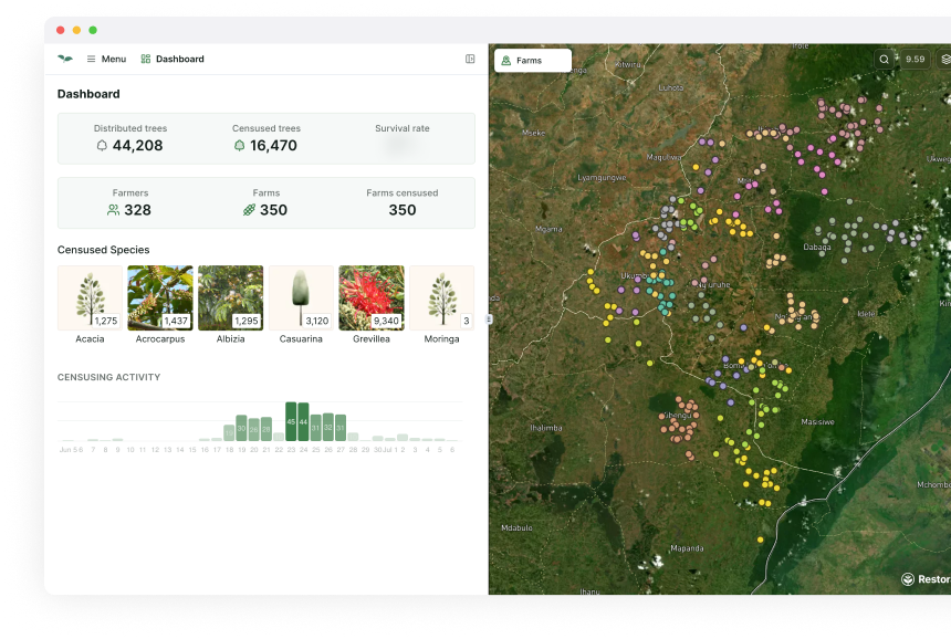
Real Estate Mapping
Lot visualisation & sales support for eco-developments. Our solutions help developers showcase property features, topography, and environmental context with stunning visual clarity.

Technology
A selection of tools & techniques we deploy:
Terrain-aware drone flight planning
Photogrammetry & 3-D reconstruction
NDVI & canopy-health analytics
AI-assisted individual-tree detection
PostGIS & cloud-native tiling
Database pipelines
Interactive User interfaces
Web mapping experiences
Where We Work
Based in the Americas, serving global projects.
San Francisco, California, USA
Headquarters
Business development, client relations, and technical leadership.
San Mateo, Alajuela, Costa Rica
R&D + Field Operations
Data collection, processing, and on-the-ground implementation.

30M
trees tracked through our systems
500
hectares of real-estate mapped
2
active continents
Ready to unlock the power of place?
Let's discuss how our geospatial solutions can transform your data into actionable insights.